Why the High Desert Can Feel So Vast
Why the high desert feels so vast: read sightlines, sparse markers, subtle ridges and light to understand the scale of a Great Basin view.
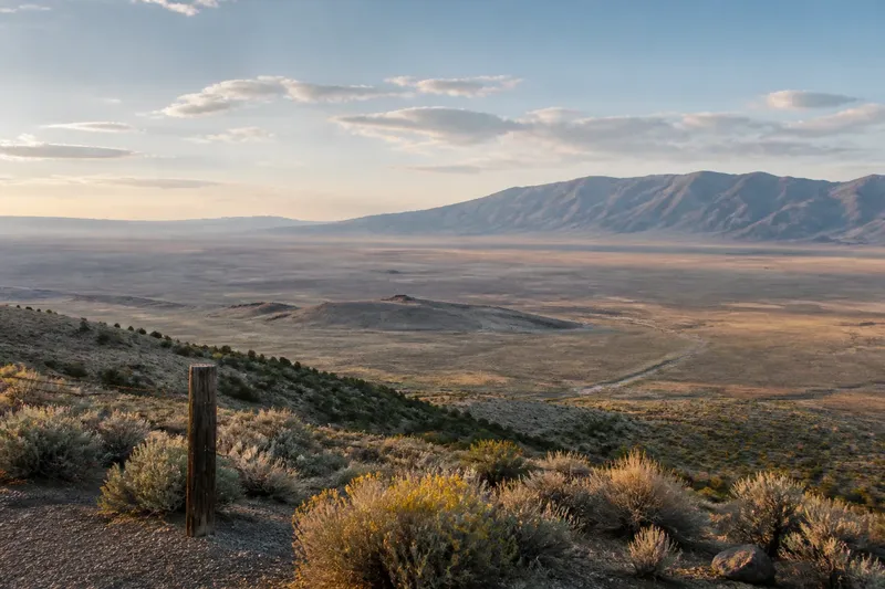
Why does the high desert feel so vast? On a Great Basin road, a low ridge can slip behind you and reveal another sweep of sagebrush, with a mountain range appearing to shift farther away. The sense of scale comes from the sightlines, scattered markers and terrain layers in view—not from emptiness.
At a safe, permitted viewpoint, compare the near ground, middle distance and horizon. Notice what interrupts each layer and how the ground rises or falls; those clues help explain why the same basin can seem to open or close.
Long sightlines make nearby ground seem small
On a level two-lane road, sagebrush, fence posts and roadside gravel may seem compressed into a narrow strip. Farther out, a long slope or distant mountain can occupy much of the view. With little dense foreground to interrupt the eye, the land between may read as one broad field rather than a sequence of separate places.
A basin-crossing road makes this effect easy to notice. A mountain range may sit at the far edge while the middle ground appears quiet, leaving few visual clues to how much country lies between them.
At a safe pull-off, compare a nearby fence post or rabbitbrush clump with a ridge in the distance. The contrast reveals layers without requiring a precise estimate. Do not stop on the carriageway or cross private land for a better view.
Sparse markers give the eye fewer comparisons
Doors, windows, signs and people provide familiar units of scale in a town. On open desert ground, the markers may be scattered: a juniper, utility pole, stock tank or road cut. The spaces between them can feel larger than they are easy to judge from a moving vehicle.
Markers also point to different features of the landscape. A cottonwood beside a wash draws attention to water-shaped terrain; fence posts reveal a boundary; a distant building indicates one point of settlement without defining the size of the valley.
Notice what a marker can and cannot tell you. Utility poles often repeat at regular intervals, while a tree may stand where water or shelter is available. Neither gives a dependable distance by itself.
Low rises reshape the horizon
High-desert elevation changes are not always dramatic. Low volcanic ridges, alluvial fans and gentle basin margins can alter a view without looking like major landforms. A small rise may hide nearby ground, then reveal another basin or mountain wall beyond it. That newly extended horizon can make the landscape feel larger.
Elevation also changes which features overlap. From a gentle slope, you may see a dry wash crossing darker scrub or a road curving behind a ridge. From below, the same ridge can hide the basin beyond. Your position changes how much land is visible, not the size of the land itself.
Compare the view from a valley floor with one from a public overlook or signed trail viewpoint. Notice which ridges conceal neighbouring slopes and whether a distant range stands apart from the sky. A map can help identify named features, but its compact symbols do not show how large or visible those features appear on the ground.
Light and air soften distant landforms
Distance can remove detail before it removes colour. A nearby slope may show individual shrubs and bands of rock, while a farther range looks smooth and muted. Dry air, haze, dust and cloud affect how clearly the eye separates one ridge from another.
Low sun may cast shadows that reveal a shallow fold; bright overhead light can flatten it. A dark patch may appear closer than a pale slope behind it. The same viewpoint can therefore look different as the light changes.
If conditions and access allow, revisit an established viewpoint at another time of day. Note which landforms stay clear and which fade into the background. Do not rely on distant landmarks for navigation when visibility is poor.
What makes a desert view feel so large?
Why can a flat basin feel larger than it looks on a map?
A basin may offer long sightlines and few objects that show how far apart its features are. The eye can register the far rim and open middle without easily judging the distance between them.
Do mountains make a landscape feel smaller?
A mountain range can provide a strong boundary, making the basin in front easier to frame. It can also emphasise the breadth of the intervening land when the foreground has few reference points.
Why does a low ridge seem to reveal more country?
From a higher position, the ridge no longer blocks the ground behind it. An additional slope, valley or horizon comes into view, making the scene seem to expand.
How can I judge distance without a clear landmark?
Compare several layers, such as roadside plants, a middle-distance wash and a far ridge, instead of relying on one object. Treat the result as an impression rather than a precise estimate, especially where the ground is open or the air is hazy.
Read the terrain without mistaking openness for emptiness
Open sightlines can conceal detail as readily as they reveal it. A shallow wash may be hard to distinguish until the light catches its banks, and low brush can hide a dip. A plain that looks uninterrupted from the road may contain changes in drainage, vegetation and surface.
Imagine you arrive at a signed public overlook above a basin. Your starting view is a broad pale floor, scattered shrubs and a dark ridge at the far edge. You look again, spot a faint wash curving across the middle ground, then notice a smaller rise partly hiding it. The result is a clearer view of how separate layers create a sense of depth and breadth, not a precise measurement.
Binoculars can help you pick out distant landforms without leaving an established viewpoint. A paper or offline map can help match visible ridges with named terrain. Watch your footing and nearby traffic, and use marked public access rather than crossing fences or entering closed areas.
Use deliberate comparisons to read the view
When you want to understand why the high desert feels so vast, compare the scene rather than searching for one dramatic landmark. Follow the view from near ground to middle distance, then trace the horizon where it meets a ridge. Ask whether the scene opens because the land drops away, you have crossed a low rise or visible markers have thinned.
- Check that your stopping place is a safe, established viewpoint; if it is signed and clear of traffic, continue observing, but if access is unclear or unsafe, choose another permitted place.
- Pick one foreground object, such as a fence post, and one distant landform; if both are visible, compare their positions, but if either is obscured, choose a clearer pair.
- Look between them for a wash, alluvial fan or low ridge; if a feature interrupts the ground, note how it divides the view, but if none is visible, treat the middle distance as unresolved rather than empty.
- Check the terrain’s shadow edges; if shadows reveal folds or banks, use them to separate layers, but if bright light flattens the ground, avoid drawing conclusions from subtle shapes.
- Compare the view from another permitted position; if a new ridge or slope appears, note how your position changed the sightline, but if the view remains blocked, stay on the established route.
- Check visibility before relying on a distant landmark; if its outline is clear, use it as a visual reference, but if haze or dust softens it, do not use it for navigation.
These comparisons help separate visible terrain from the impression of scale. A basin may feel boundless when its edges are faint, then become easier to read as ridges, washes and scattered markers resolve into layers. Let the horizon set the scene, and use the terrain to explain what you see.